23 December 2013
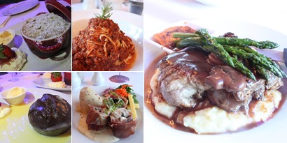
The Views, Halls Gap
Grampians (McKenzie Falls, Briggs Bluff)–Day 2
I have a love-hate relationship with hiking. "Hate" - the journey to the summit is likened to swallowing a bitter pill. It's more of a test of patience rather than endurance. The closer you get to the top, it appears that the summit is drifting farther away, with no end in sight. "Love" - once I get a first glimpse of the view from the summit, I am filled with supreme joy.
Oh, did I mention that we bunked in a three-bed dorm room (1 queen size bed and 1 bunker bed, AUD98 per night) at Grampians Eco YHA, Halls Gap for the night? The room was really clean, comfortable and had patio doors which opened out to a courtyard area. The kitchen is spacious and well equipped with stoves, fridges, microwave ovens, plates and cutleries. The TV room is a great place to chill out and relax.
For breakfast, we gobbled down some red bean buns and leftover party pastries, before setting off for McKenzie Falls. It is impossible to visit Grampians without going to McKenzie Falls. Standing over 30 metres in height, this largest waterfall in Victoria is one of only a handful of spills that flow all year round. From MacKenzie Falls Car Park, we veered right from fork of the trail and took an easy 1km stroll towards the viewing platform.
After, capturing a few shots of this majestic fall, we returned to the fork and started our 0.75km descent towards the base of MacKenzie Falls. Half-way down the trail and there were still no tourist in sight, hence we shamelessly, climbed over the railings and carefully inched our way towards the edge of the anterior end of the fall. For a moment, I feel like a trespasser, but who cares!!
Me, “trespassing”. I bet I’m not the first and last to do so
It feels amazing sitting there, immersing yourself in the moment the tranquillity while streams of water pass you by. I could sit here forever, but the grandeur of the great MacKenzie Falls awaits us at the base. Time to move it move it. We gotta move it move it.
Streams of water cascading down huge cliffs into a deep pool that narrows into Mackenzie River
Within seconds, the base transformed from a silent solitude to a tourist fest. Hence, we decided to leave for lunch before the 5.3km hike to Briggs Bluff. Speaking of lunch, I had the weirdest meal ever! Picture this, peanut butter, raw cabbage leaves, potato chips, tuna chunks wrapped in tortillas or even worst – two bars of Snickers, tuna chunks and raw cabbage!! So how did it taste like? Stay tuned for my post on “Idiotic Stuff to do in Grampians”.
Carb loading done, sunscreen applied liberally, water bottles packed and we’re ready for a much anticipated hike. The first part of the trail is 1.3km to Beehive Falls, which was a flat and wide dirt track. Initially we weren't sure how it'll look like, but expected sounds of pouring water that will eventually guide us to the waterfall. Instead we came across this.
Beehive Falls without the fall - Dry as a bone
After this, the trail squeezes into a steep ascend. In geographical terms a ‘bluff’ according to the freedictionary.com is “a steep promontory, bank, or cliff, particularly one formed by river erosion on the outside bend of a meander”. However, I reckon the name Briggs Bluff suggests otherwise, as it’s easy for one to lose the trail (especially during the descend) because lines of flat rocks go off in different directions. Even with a compass, and brochure map in hand, we somehow manage to get lost several times. As if, hours traipsing on uneven tracks weren’t enough, for most parts, we had to clamber up slopes of loose rocks and near vertical sandstones.
Follow the yellow arrows
I posted these photos, to give a sense of the size and steepness of our passage. 5 hours of these, amazingly fun. When I said fun, I meant gruelling, at least for someone who had virtually no experience with near vertical sandstones. I had to grip tightly onto the sandstones and haul myself up. Every step I took, I wonder how in the world am I gonna get down?! No time for self-pity, we had to trudge onwards and upwards. Well, the journey wasn’t that all arduous, as we were treated onto the first plateau where the view of Briggs Bluff was finally insight. After ~1km, the route loops into the main plateau, through a rock arch and arriving at an intersection.
Unfortunately, our navigation skills were not perfect. From an intersection, we veered right instead of left and found ourselves walking aimlessly towards Mount Difficult. It wasn't until we came across three girls whom like us, took the wrong path. Hence, we turned around, went all the way back to the intersection and found the proper trail head for Take 2 i.e. left.
Again, hauling ourselves up the rock face with our hands, we finally reached the last phase of the trek and made it to the summit.
Looking out from Briggs Bluff over the Western Victorian plans and the Northern Grampians, was a surreal and profoundly satisfying. 30 hours prior to this moment, I was trembling at Boronia Peak as I allowed my fear of heights to dominate my being. At this point in time, I won’t profess that I am Spiderman, but me being able to stand calmly at the edge of the cliff (well nearly), tells me that Achilles heel of mine is ‘curable’.
Our return journey back down the same route wasn’t the smoothest descent as we had to detour a few times before we located the next yellow arrow. That involved clambering up and down steep rocky peaks numerous times. My advice would be to take note of the small markers of passage on your way up.
All in all, the trip to Grampians was all I wanted and more. Great workout, great scenic views and great company. Though it’s a short weekend getaway, there’s so many elements to Grampians that I would like to put together including a comprehensive tourist guide, a food review of The Views Restaurant and a post on “Idiotic stuff to do in Grampians”. So stay tuned.
19 December 2013
Grampians (Mt Williams, Boroka Lookout, Reeds Lookout, the Balconies, the Pinnacle)
Mount Williams Summit
Following Boronia Peak, we made our way to Mount Williams Summit, the highest point within the Grampians National Park. We drove to Mount Williams Carpark, then proceeded on foot for 1.8km to the summit via a sealed road.
Strenuous walking involved. I repeat…..strenuous walking involved.
The path started off with a steep inclination and trailed off into a plateau towards the end.
See the whitish tree brunches with blackened spots, I reckon they’re part of the remains from the 2006 major bushfire which burnt a large section of the area.
Panaromic view of the eastern vantage from Mount William, towards Ararat.
We made a few idiotic poses for the camera from push-ups to martial art poses to filming a parody of the scene from Lion King where Rafiki presents Simba to the Pride Lands. I shall include this in a separate post, which I’m dying to put together – “Idiotic Stuff to Do in Grampians”. We could have stayed longer and continue to act like fools on the summit but the chill of the weather urged us to hustle back to the car and make our way to Boroka Lookout.
Boroka Lookout
The walk to the lookout point from the carpark was easy-peasy-lemon-squeezy. I shall cherish this moment. Take a mere 10 seconds walk and you’ll find yourself overlooking the spectacular 180 degree views out over the the north and east regions and over Halls Gap and Lake Bellfield to the south. After spending ~15 minutes admiring the awe inspiring view, we proceeded to Reed Lookout/ The Balconies.
Did I mention it is beautiful? Because it is!! You can even point out Lake Lonsdale and Lake Fyans from a distance.
Reed Lookout/ The Balconies Lookout
To get to the Balconies, take a relatively easy 1km stroll along a gravelled trail where you’ll come across wooden chairs carved out from tree trunks and mini stone henges resting on rock outcrops.
After what felt like forever into the stringybark (Eucalyptus) forest, I finally laid eyes on this beauty.
I saw people clambered pass the steep edges of the rocks then balance on their two feet like a stork at the tip of the cliff, posing for the camera. Something in me wanted to scream: “Are you out of your freaking mind?!”. Anyone that knows me, knows I crave adventure and an adrenaline spike. Yes, it would be exhilarating to tempt fate but for me, I crawled to the edge, looked down, snapped a quick photo, then quickly scurry back to safety before the wooziness kicks in. Better safe than sorry, one misstep and it’s hasta la vista.
By the time we returned to Reeds Carpark, the time displayed on my watch was 3:45pm. Signs of exhaustion were beginning to show and our knees were starting to feel ancient. However, we still yet to make a 20 minutes drive to Wonderland Carpark and complete another hike to the Pinnacle.
The Pinnacle via Grand Canyon
The Pinnacle is a popular attraction for day trippers. From Wonderland Carpark, it’s an alleged 0.1km walk to the Grand Canyon and a 2.1km hike to the Pinnacle. Note that I mentioned “alleged”, because it feels like much longer and an effort of a 10km run. Despite the fact that it isn’t the most challenging trek, by the time we reached the end of Grand Canyon, we were laughing at the distance. They must have gotten the signage wrong. Another option is to bypass the Grand Canyon but I must say that it is one of the most unique and inviting site of the Grampians. You wouldn’t want to give it a miss.
Like most walkers, we veered left towards the Grand Canyon track; veer right and you’ll ascend directly to the pinnacle bypassing the Grand Canyon. Following the small yellow arrows painted on the rocks we began the uphill walk.
Half an hour in and I found myself panting away, hopping from one rock to the next. The trail ahead seemed like a never ending series of ragged sandstone formations.
The Grand Canyon houses massive stacks of rocks, neatly balance precariously on top of one another. This hard sandstone nature was formed after thick layers of sediments were intensely folded and thrust up from under the earth dating back to 430 million years ago, making human existence on earth seem tiny in comparison.
As you can see, there are metal railings and stairways along the gorge at various section, however most sections involves rock-hopping and uneven surfaces. All you need is yourself and a pair of good gripping shoes. Ironically, I was surprised at how many people were in sandals and worse – dressed up as if they’re heading to the mall.
Once we approached the Pinnacle, instead of heading to the strategically placed fenced platform, I immediately head to the massive cliff situated adjacent to it, clambered to the edge of the cliff, well nearly and set there for what felt like eternity.
After perching on that cliff for 15 minutes or so, I finally clomped my way up the the Pinnacle lookout. Again amazing view.
Having taken various shots at the top, we finally made our descend and head back to Halls Gap.
Last stretch of sandstones for the day
First order of business: A much needed shower
Second order of business: A well deserved hearty dinner at the View Restaurant. How good is the food? I shall elaborate in detail in another post. For now, I would say it’s a MUST GO.
Third order of business: A game of 500 (card game).
18 December 2013
Grampians Challenge (Itinerary, Boronia Peak)
- Melbourne CBD –> Ballarat –> Ararat –> Halls Gap
- Boronia Peak (Medium, ~ 2 hours, 6.6km return)
- Mt Williams Summit (Medium, ~ 1 hour, 3.6km return)
- Boroka Lookout (Easy)
- Reed Lookout/ the Balconies (Easy, ~45 mins, 2km return)
- Pinnacle via Grand Canyon (Hard, ~2-3 hours, 4.2km return)
- Dinner at The Views (#1 on TripAdvisor)
- Mackenzie Falls (Medium, ~1 hour, 2km return)
- Briggs Bluff via Beehive Falls (Hard, ~5-6 hours, 10.6km return)
1
2
3
4
5
6
7
8
9
10